Woerden
Penampilan
Woerden | |
|---|---|
Bandar dan kawasan perbandaran | |
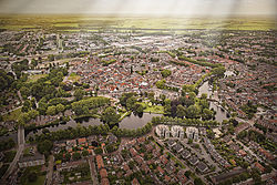
 Pandangan atas di Woerden pada 2013 | |
 Lokasi di Utrecht | |
| Koordinat: 52°5′N 4°53′E / 52.083°N 4.883°EKoordinat: 52°5′N 4°53′E / 52.083°N 4.883°E | |
| Negara | Netherlands |
| Wilayah | Utrecht |
| Pentadbiran | |
| • Badan | Majlis perbandaran |
| • Datuk Bandar | Victor Molkenboer (PvdA) |
| Keluasan | |
| • Jumlah | 92.92 km2 (35.88 batu persegi) |
| • Tanah | 89.35 km2 (34.50 batu persegi) |
| • Air | 3.57 km2 (1.38 batu persegi) |
| Aras | 0 m (0 ft) |
| Penduduk (Ogos 2017)[4] | |
| • Jumlah | 51,729 |
| • Kepadatan | 579/km2 (1,500/batu persegi) |
| Demonim | Woerdenaar |
| Zon waktu | UTC+1 (CET) |
| • Musim panas (DST) | UTC+2 (CEST) |
| Poskod | 3440–3449, 3470–3481 |
| Nombor pendailan | 0348 |
| Laman sesawang | www |
Woerden (Sebutan Belanda: [ˈʋuːrdə(n)]) merupakan sebuah gemeente Belanda yang terletak di wilayah Utrecht. Pada tahun 2006 daerah ini memiliki penduduk sebanyak 47,872 orang.
Lihat juga
[sunting | sunting sumber]Rujukan
[sunting | sunting sumber]- ^ "Burgemeester V.J.H. (Victor) Molkenboer" [Mayor V.J.H. (Victor) Molkenboer] (dalam bahasa Belanda). Gemeente Woerden. Dicapai pada 11 April 2014.
- ^ "Kerncijfers wijken en buurten" [Key figures for neighbourhoods]. CBS Statline (dalam bahasa Dutch). CBS. 2 July 2013. Dicapai pada 12 March 2014.CS1 maint: unrecognized language (link)
- ^ "Postcodetool for 3447GR". Actueel Hoogtebestand Nederland (dalam bahasa Dutch). Het Waterschapshuis. Dicapai pada 11 April 2014.CS1 maint: unrecognized language (link)
- ^ "Bevolkingsontwikkeling; regio per maand" [Pertumbuhan populasi; kawasan per bulan]. CBS Statline (dalam bahasa Belanda). CBS. 27 Oktober 2017. Dicapai pada 27 Oktober 2017.


