Pengguna:Azuru79/Kotak pasir/Kotak info petempatan/kes ujian
Penampilan
Los Angeles | |||||||||
|---|---|---|---|---|---|---|---|---|---|
| City of Los Angeles (Inggeris) (Bandar Los Angeles) | |||||||||
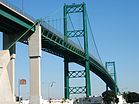
Clockwise from top: Downtown seen from the southwest, Griffith Observatory, the Theme Building at Los Angeles International Airport, Venice Beach, Vincent Thomas Bridge, City Hall and the Hollywood Sign | |||||||||
| Nama panggilan: LA, City of Angels,[1] The Entertainment Capital of the World, The Big Orange,[1] La-la-land, Tinseltown[1] | |||||||||
 Interactive map outlining Los Angeles | |||||||||
| Koordinat: 34°03′N 118°15′W / 34.050°N 118.250°WKoordinat: 34°03′N 118°15′W / 34.050°N 118.250°W | |||||||||
| Country | |||||||||
| State | |||||||||
| County | |||||||||
| CSA | Los Angeles-Long Beach | ||||||||
| MSA | Los Angeles-Long Beach-Anaheim | ||||||||
| Pueblo | September 4, 1781[2] | ||||||||
| City status | May 23, 1835[3] | ||||||||
| Incorporated | April 4, 1850[4] | ||||||||
| Dinamai sempena | Our Lady, Queen of the Angels | ||||||||
| Kerajaan | |||||||||
| • Jenis | Mayor-Council-Commission[5] | ||||||||
| • Mayor | Eric Garcetti[6] | ||||||||
| • City Attorney | Mike Feuer[6] | ||||||||
| • City Controller | Ron Galperin[6] | ||||||||
| Luas | |||||||||
| • Total | 502.76 batu persegi (1,302.15 km2) | ||||||||
| • Darat | 468.74 batu persegi (1,214.03 km2) | ||||||||
| • Air | 34.02 batu persegi (88.12 km2) 6.7% | ||||||||
| Ketinggian | 305 ft (93 m) | ||||||||
| Paras tertinggi | 5,074 ft (1,547 m) | ||||||||
| Paras terendah | 0 ft (0 m) | ||||||||
| Penduduk | |||||||||
| • Total | 3,792,621 | ||||||||
| • Anggaran (2017)[11] | 3,999,759 | ||||||||
| • Kedudukan | 1st, California 2nd, U.S. | ||||||||
| • Kepadatan | 8,483.02/batu persegi (3,275.32/km2) | ||||||||
| • Urban | 12,150,996 | ||||||||
| • Metro | 13,131,431 (U.S.: 2nd) | ||||||||
| • CSA | 18,679,763 (U.S.: 2nd) | ||||||||
| Demonym(s) | Angeleno | ||||||||
| Zon waktu | UTC−08:00 (Pacific) | ||||||||
| • Musim panas (DST) | UTC−07:00 (PDT) | ||||||||
| ZIP Codes | Senarai
| ||||||||
| Area codes | 213/323, 310/424, 747/818 | ||||||||
| FIPS code | Templat:FIPS | ||||||||
| GNIS feature IDs | 1662328, 2410877 | ||||||||
| Primary Airport | Los Angeles International Airport | ||||||||
| Secondary Airports | Hollywood Burbank Airport Van Nuys Airport Long Beach Airport | ||||||||
| Interstates | |||||||||
| U.S. Highways | |||||||||
| State Routes | |||||||||
| Rapid Transit | |||||||||
| Commuter Rail | |||||||||
| Laman web | Tapak web rasmi | ||||||||
Rujukan
[sunting | sunting sumber]- ^ a b c Gollust, Shelley (April 18, 2013). "Nicknames for Los Angeles". Voice of America. Dicapai pada June 26, 2014.
- ^ Barrows, H.D. (1899). "Felepe de Neve". Historical Society of Southern California Quarterly. 4. m/s. 151ff. Dicapai pada September 28, 2011.
- ^ "This 1835 Decree Made the Pueblo of Los Angeles a Ciudad – And California's Capital". KCET. April 2016. Dicapai pada January 27, 2018.
- ^ "California Cities by Incorporation Date". California Association of Local Agency Formation Commissions. Diarkibkan daripada yang asal (Word Document) pada February 21, 2013. Dicapai pada August 25, 2014. Unknown parameter
|dead-url=ignored (bantuan) - ^ "About the City Government". City of Los Angeles. Diarkibkan daripada yang asal pada Februari 8, 2015. Dicapai pada Februari 8, 2015. Unknown parameter
|dead-url=ignored (bantuan) - ^ a b c "City Directory". City of Los Angeles. Diarkibkan daripada yang asal pada November 13, 2014. Dicapai pada September 28, 2014. Unknown parameter
|deadurl=ignored (bantuan) - ^ "2016 U.S. Gazetteer Files". United States Census Bureau. Dicapai pada June 28, 2017.
- ^ Templat:Cite GNIS
- ^ a b "Elevations and Distances". US Geological Survey. April 29, 2005. Dicapai pada February 10, 2015.
- ^ "CA Dept. of Finance - New State Population Report" (PDF). Dicapai pada July 2, 2016.
- ^ "American FactFinder". Dicapai pada May 25, 2018.
- ^ "Urban Areas". United States Census Bureau. Diarkibkan daripada yang asal pada May 16, 2012. Dicapai pada August 29, 2014. Unknown parameter
|dead-url=ignored (bantuan)https://www.census.gov/geo/reference/ua/urban-rural-2010.html - ^ "Annual Estimates of the Resident Population: April 1, 2010 to July 1, 2013 – United States – Combined Statistical Area; and for Puerto Rico". Census Bureau. Census Bureau. Diarkibkan daripada yang asal pada August 15, 2014. Dicapai pada August 29, 2014. Unknown parameter
|deadurl=ignored (bantuan) - ^ Zip Codes Within the City of Los Angeles - LAHD
- ^ "Annual Estimates of the Resident Population: April 1, 2010 to July 1, 2013 – United States – Metropolitan Statistical Area; and for Puerto Rico". United States Census Bureau. Diarkibkan daripada yang asal pada August 15, 2014. Dicapai pada August 29, 2014. Unknown parameter
|deadurl=ignored (bantuan)


