Kota Daud
Koordinat: 31°46′25″N 35°14′08″E / 31.77361°N 35.23556°E
| עיר דוד | |
 | |
| Ralat Lua pada baris 511 di Modul:Location_map: Tidak dapat cari takrifan peta lokasi yang ditentukan: "Modul:Peta lokasi/data/Baitulmaqdis Lam" tidak wujud. | |
| Nama alternatif | Ir David (dalam Ibrani) |
|---|---|
| Lokasi | Baitulmaqdis |
| Jenis | penempatan |
| Sejarah | |
| Zaman | Zaman Gangsa – Rom Timur |
| Budaya | Kanaan, Israel, Agama Yahudi Kuil Kedua, Rom Timur |
| Peristiwa | Pengepungan Jebus, Pengepungan Assyria ke atas Baitulmaqdis, Pengepungan Babylon ke atas Baitulmaqdis |
| Perincian tapak | |
| Ahli arkeologi | Charles Warren, Conard Schick, K.M. Kenyon, Yigal Shiloh, Ronny Reich, Eli Shukron, Doron Ben-Ami, Eilat Mazar dan lain-lain |
| Keadaan | dalam runtuhan |
| Pengurusan | Pihak Berkuasa Taman dan Alam Semula Jadi Israel, Yayasan Ir David |
| Akses awam | Ya |
| Tapak sesawang | www |
| Sebahagian daripada siri berkaitan |
| Baitulmaqdis |
|---|
 |
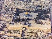
Kota Daud (Ibrani: עיר דוד, rumi: ʿĪr Davīd), atau secara tempatan dinamakan Wadi Helwah (Arab: وادي حلوة),[1] ialah nama yang diberikan kepada sebuah tapak arkeologi dianggap oleh kebanyakan sarjana sebagai teras penempatan asal Baitulmaqdis semasa Zaman Gangsa dan Besi.[2][3][4][5][6] Ia terletak di bahagian selatan rabung timur Baitulmaqdis purba,[5] barat Lembah Kidron dan timur Lembah Tyropoeon, hingga ke selatan Bukit Kuil.
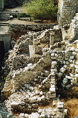
Kota Daud ialah tapak penting dalam arkeologi Alkitab. Sisa rangkaian pertahanan perang sejak Zaman Gangsa Pertengahan ditemui di sekitar Mata Air Gihon; ia terus kekal digunakan sepanjang tempoh berikutnya. Dua struktur monumen Zaman Besi, yang dikenali sebagai Struktur Batu Besar dan Struktur Batu Berlangkah, ditemui di tapak tersebut. Sarjana berdebat sama ada ini boleh dikenal pasti beriringan dengan zaman Daud atau tarikh selepasnya. Tapak ini juga menempatkan Terowong Siloam, yang mana, menurut hipotesis biasa, telah dibina oleh Hezekiah pada akhir abad ke-8 SM sebagai persediaan untuk pengepungan Assyria. Walau bagaimanapun, penggalian baru-baru ini di tapak mencadangkan asal usul lebih awal pada akhir abad ke-9 atau awal abad ke-8 SM.[7][8] Tinggalan dari zaman Rom awal termasuk Kolam Siloam dan Jalan Berlangkah, yang terbentang dari kolam ke Bukit Kuil.[9]
Bahagian tapak arkeologi yang digali kini adalah sebahagian daripada Taman Negara Tembok Baitulmaqdis.[a][11] Tapak ini diuruskan oleh Pihak Berkuasa Taman dan Alam Semula Jadi Israel dan dikendalikan oleh Yayasan Ir David. Ia terletak di Wadi Helwah, lanjutan kejiranan orang Palestin Silwan, Baitulmaqdis Timur, yang saling berkaitan dengan penempatan Israel.


Pautan Pilihan
[sunting | sunting sumber]| Wikimedia Commons mempunyai media berkaitan Kota Daud |
Rujukan
[sunting | sunting sumber]- ^ Jeffery Yas (2000). "(Re)designing the City of David: Landscape, Narrative and Archaeology in Silwan". Jerusalem Quarterly. Dicapai pada 18 April 2023.
Known to archaeologists and Biblical scholars as the site of the City of David, the western slope of the Kidron valley is referred to locally by a variety of aliases, and among them "Wadi Hilwe" (in English, "Beautiful Valley") seems to prevail.
- ^ Ariel, D. T., & De Groot, A. (1978). "The Iron Age extramural occupation at the City of David and additional observations on the Siloam Channel." Excavation at the City of David, 1985.
- ^ Broshi (1974), pp. 21–26.
- ^ Reich, R., & Shukron, E. (2000). "The Excavations at the Gihon Spring and Warren's Shaft System in the City of David." Ancient Jerusalem Revealed. Jerusalem, 327–339.
- ^ a b Geva & De Groot (2017, pp. 32–49) "The prevailing view among researchers that the early city, the City of David, lay in the southern part of the eastern ridge next to the spring."
- ^ Gadot dll. 2023, m/s. 165.
- ^ Ronny Reich and Eli Shukron (2011). "The date of the Siloam Tunnel reconsidered". Tel Aviv. 38 (2): 147–157. doi:10.1179/033443511x13099584885268. S2CID 191493893.
- ^ Alon De Groot and Fadida Atalya (2011). "The Pottery Assemblage from the Rock-Cut Pool near the Gihon Spring". Tel Aviv. 38 (2): 158–166. doi:10.1179/033443511x13099584885501. S2CID 128741871.
- ^ Szanton, Nahshon; Uziel, Joe (2016). "Jerusalem, City of David [stepped street dig, July 2013 - end 2014], Preliminary Report (21/08/2016)". Hadashot Arkheologiyot. Israel Antiquities Authority. Dicapai pada 24 July 2020.
- ^ Galor 2017, m/s. 61.
- ^ Greenberg 2014, halaman 29: "Contrast these rather upbeat examples of ethical praxis in public archaeology with the situation in the Wadi Hilweh neighborhood in Silwan, built on the ancient mound of Jerusalem, just south of the Haram esh-Sharif (Temple Mount). Here, the material remains of the past have become completely absorbed in the discourse of political power, as both the Israeli national project of unifying Jerusalem and the settler project of breaking Palestinian Jerusalem apart have joined to disenfranchise the people living above and among the antiquities. The archaeology practiced here is completely subsumed to political and corporate motivations that are, however, largely unacknowledged by its "neutral" practitioners, leading to questionable field practice and overtly skewed interpretations of the past. Instead of going into detail about the issues of excavation and interpretation, which I have discussed at length elsewhere (Greenberg 2008, 2009), I would like to consider if there is any way out of the predicament that is, if there is a way to conduct archaeology ethically in Silwan."
Ralat petik: Tag <ref> wujud untuk kumpulan bernama "lower-alpha", tetapi tiada tag <references group="lower-alpha"/> yang berpadanan disertakan
