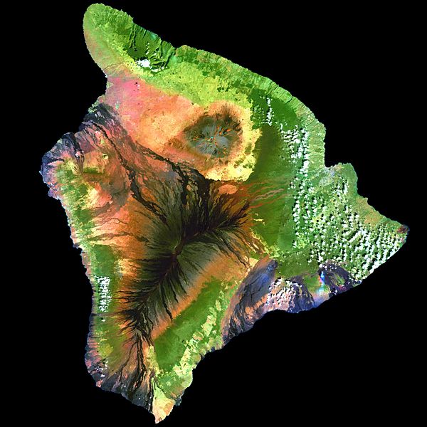
Fail:Island of Hawai'i - Landsat mosaic.jpg
Penampilan

Saiz pralihat ini: 600 × 600 piksel. Leraian-leraian lain: 240 × 240 piksel | 480 × 480 piksel | 768 × 768 piksel | 1,024 × 1,024 piksel | 2,048 × 2,048 piksel | 5,076 × 5,076 piksel.
Fail asli (5,076 × 5,076 piksel, saiz fail: 5.19 MB, jenis MIME: image/jpeg)
Sejarah fail
Klik pada tarikh/waktu untuk melihat rupa fail tersebut pada waktu itu.
| Tarikh/Waktu | Gambar kenit | Ukuran | Pengguna | Komen | |
|---|---|---|---|---|---|
| semasa | 11:59, 1 September 2009 |  | 5,076 × 5,076 (5.19 MB) | Túrelio | saved with 95% quality (low compression), but without "progressive" option |
| 11:59, 1 September 2009 |  | 5,076 × 5,076 (4.9 MB) | Bidgee | Fix thumbnail generation issue caused by progressive loading. | |
| 11:31, 1 September 2009 |  | 5,076 × 5,076 (4.91 MB) | Rocket000 | reuploading | |
| 11:52, 27 Disember 2007 |  | 5,076 × 5,076 (4.91 MB) | Avenue | {{Information| |Description=This simulated true-color image of the island of Hawai'i was derived from data gathered by the Enhanced Thematic Mapper plus (ETM+) on the Landsat 7 satellite between 1999 and 2001. |Source=[http://veimages.gsfc.nasa.gov/2712/l |
Penggunaan fail
Laman berikut menggunakan fail ini:
Penggunaan fail sejagat
Fail ini digunakan oleh wiki-wiki lain yang berikut:
- Penggunaan di af.wikipedia.org
- Penggunaan di ar.wikipedia.org
- Penggunaan di ast.wikipedia.org
- Penggunaan di az.wikipedia.org
- Penggunaan di be.wikipedia.org
- Penggunaan di bn.wikipedia.org
- Penggunaan di br.wikipedia.org
- Penggunaan di ca.wikipedia.org
- Penggunaan di ceb.wikipedia.org
- Penggunaan di cy.wikipedia.org
- Penggunaan di de.wikipedia.org
- Penggunaan di de.wikivoyage.org
- Penggunaan di en.wikipedia.org
- Hawaii (island)
- Mauna Loa
- Landsat program
- Geoinformatics
- Puna, Hawaii
- User:Spikebrennan
- Portal:Hawaii/Selected article
- Portal:Hawaii/Selected article/11
- Wikipedia:Featured picture candidates/February-2008
- Wikipedia:Featured picture candidates/Big Island of Hawai'i
- User:Hawaiian Mafia
- User:Aoi/sandbox
- Penggunaan di es.wikipedia.org
- Penggunaan di es.wikibooks.org
- Penggunaan di eu.wikipedia.org
- Penggunaan di fa.wikipedia.org
- Penggunaan di fr.wikipedia.org
- Penggunaan di fr.wikivoyage.org
- Penggunaan di ga.wikipedia.org
- Penggunaan di gl.wikipedia.org
- Penggunaan di haw.wikipedia.org
- Penggunaan di he.wikipedia.org
- Penggunaan di hi.wikipedia.org
- Penggunaan di hu.wikipedia.org
- Penggunaan di ia.wikipedia.org
- Penggunaan di id.wikipedia.org
- Penggunaan di incubator.wikimedia.org
- Penggunaan di is.wikipedia.org
- Penggunaan di ja.wikipedia.org
Lihat banyak lagi penggunaan sejagat bagi fail ini.

